In 2023, we earned the "Best Maintained Dam Local Public Category" from the Water Management Association Organization of Ohio.
Your Money | What's NEW?
In 2024, we continued our routine maintenance of removing downed trees from the maintenance berms and channels. The trees were removed from these areas to prevent logjams and to allow access needed to do channel inspections and channel mowing. We have been working over the past couple of years to reestablish sections of the maintenance berm that have not had any maintenance done for a few years.
This past year, we reestablished 1.5 miles of maintenance berm, the reestablished section will be added to our mowing program and will be mowed on an annual basis. We also continued our maintenance program on the 8 flood control dams. The dams were mowed 4 times in 2024 to maintain the sod cover and aid in the ease of inspections. With our routine maintenance and regular inspections, all our dams currently meet ODNR Safety requirements.
In 2023, we earned the 2023 ODSO Dam Safety Award for Best Maintained Dam in the state of Ohio. The award is given in recognition of establishing a consistent pattern of inspection, maintenance both within the dam structure and surrounding areas.
During our regular inspections this year, it was observed that the lake drain valve on dam IV-A did not function correctly and needed to be replaced. The pool area of the dam was drained to allow contractors to enter the inlet structure where the valve is located approximately 20’ below the normal water surface. The contractor removed the valve and replaced it with the same model and style of valve. After the valve was replaced, the pool area was filled to its normal water level.
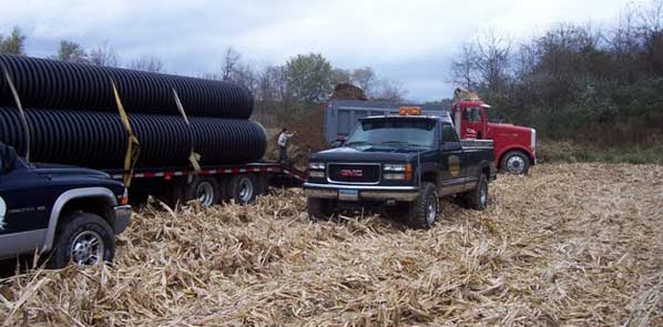
Part of the maintenance program is to inspect and maintain the 600 drainage structures located along the channels. An excellent example of this was a large culvert that needed replacement on the River Styx channel. This structure was made of corrugated metal pipe and had deteriorated over the past 50 years and was beginning to fail impacting the maintenance berm along the River Styx Channel. This structure was replaced with corrugated N-12 pipe to ensure that it will function for many more years. Going into 2025, we will continue our focus on the maintenance and inspections of the channels and dams.
"Are maintenance or flowage easements on my property?" is a frequently asked question. To help you see where the easements are situated, we have developed the Chippewa Subdistrict Dynamic Map. Click the link to see your property. Similar in operation to a Google map, zoom in for more detail, use the mouse cursor to drag your viewpoint side to side or up and down.
The eight Chippewa Dams range in age from 40 – 50 years old. In 2024, we continuer to focus on the maintenance and inspections of the channels and dams. We work to keep them in excellent condition, which requires regular inspection and monitoring. How do you safely inspect concrete spillway pipes and that are buried deep, and hundreds of feet long?
See Hubbard Valley Dam Laser Scanning Project.
Channel Maintenance
Vegetation management is key to preserving channel capacity for flow, and for providing access for maintenance activities along the 33 miles of channel that we are responsible for.
Dam Maintenance
Dam inspections, regular servicing and consistent mowings are key to maintaining dam's ability to function as intended. Chippewa subdistrict manages 8 dams.
Special Projects
An example of a special project this year was on the River Styx, with bank restoration & replacement of a 42' culvert. The pipe structure was made of corrugated metal pipe and had deteriorated over the past 50 years and was beginning to fail, impacting the river bank, and the maintenance berm along the River Styx Channel. This structure was replaced with corrugated N-12 pipe to ensure that it will function for many more years, and the bank was restored and seeded.The pipe structure was made of corrugated metal pipe and had deteriorated over the past 50 years and was beginning to fail impacting the river bank, and the maintenance berm along the River Styx Channel. This structure was replaced with corrugated N-12 pipe to ensure that it will function for many more years, and the bank was restored and seeded.
Hubbard Valley Dam Laser Scanning Project
We initiated our first laser scan and 3D basemap of a Principal Spillway structure in 2019 and have continued to leverage that data. At Hubbard Valley Dam, (Dam 3-A), the spillway consists of a 25 foot tall concrete riser, 42-inch diameter by 236 foot long outlet pipe and impact basin. GPD Group – Akron was the contractor. The initial report and drawings provided a very detailed basemap of the spillway. Comparisons of the initial basemap and subsequent scans, will indicate any possible compromises of the structure or the pipe. This level of detail will supplement more basic visual inspections.
StormLink® Instrumentation at Dam 5-D
We installed our third Automated Rainfall and Stage Level Monitoring System with a StormLink® Satellite Monitoring Station in 2019 and utilized that data in 2020. The StormLink® is installed on Dam 5-D, off Steiner Road near Creston, Muskingum Watershed Conservancy District (MWCD) staff installed conduit, concrete supports, and the solar-powered station. We are continuing to monitor the site remotely for rainfall and flood pool stage, which is especially important during large storm events.